Groundwater Sustainability
Studying aquifer depletion, irrigation capacity decline, and agricultural transition pathways in groundwater-dependent regions.
Researcher · Nelson Institute SAGE · UW–Madison
I develop data-driven models and decision-support tools to evaluate agricultural adaptation to water scarcity, with emphasis on groundwater-dependent regions, irrigation technology, crop choice, and land-use transitions.

My research focuses on how agricultural systems adapt to water scarcity, groundwater depletion, and changing economic conditions. I combine agricultural economics, geospatial analysis, hydro-economic modeling, and optimization to evaluate irrigation transitions, crop choice, land-use change, and decision-support strategies.
Studying aquifer depletion, irrigation capacity decline, and agricultural transition pathways in groundwater-dependent regions.
Evaluating irrigation investments, pumping costs, crop profitability, and water-use decisions under changing hydrologic and economic conditions.
Integrating GIS, remote sensing, county-level crop data, climate variables, soil data, and groundwater datasets for regional agricultural systems analysis.
Developing applied tools using Excel/VBA, Python, ArcGIS, and GAMS to support irrigation planning and agricultural adaptation analysis.
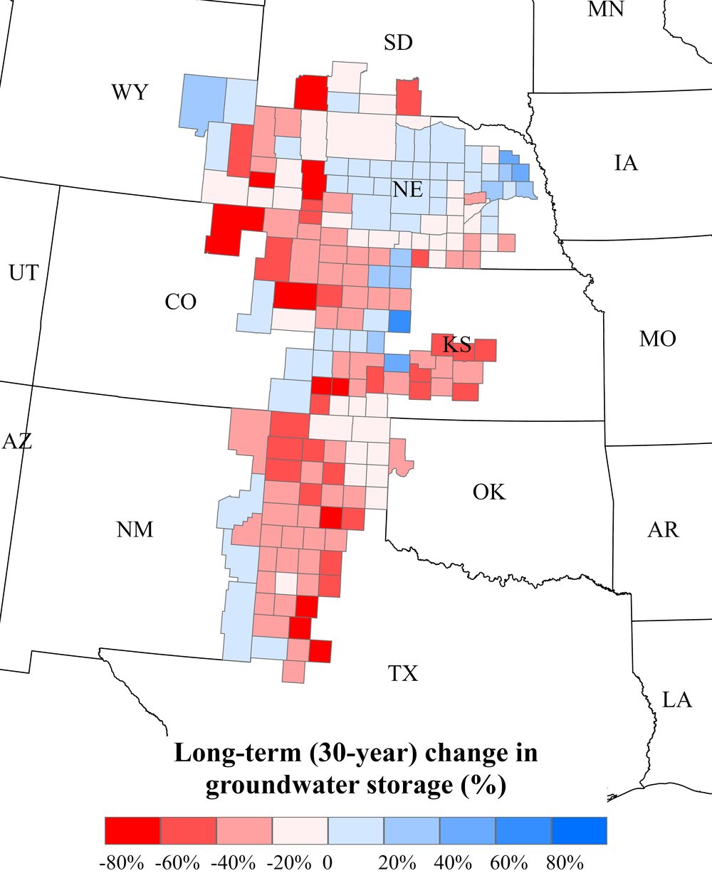
Irrigated agriculture across the United States, and county-scale results from my hydro-economic modeling of the High Plains Aquifer: where groundwater is declining fastest, when irrigated maize is likely to give way to dryland systems, and where perennial bioenergy crops could take its place.
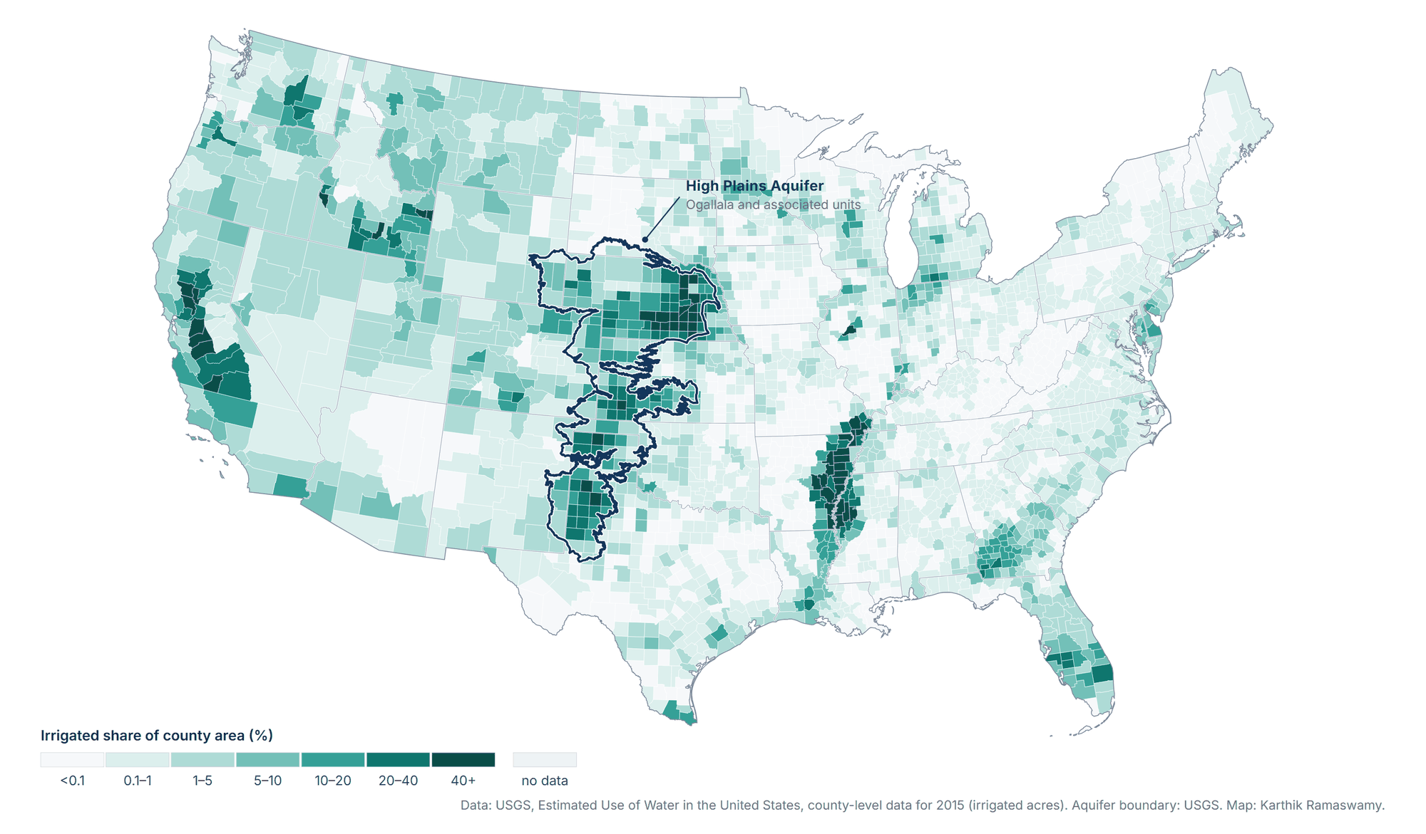
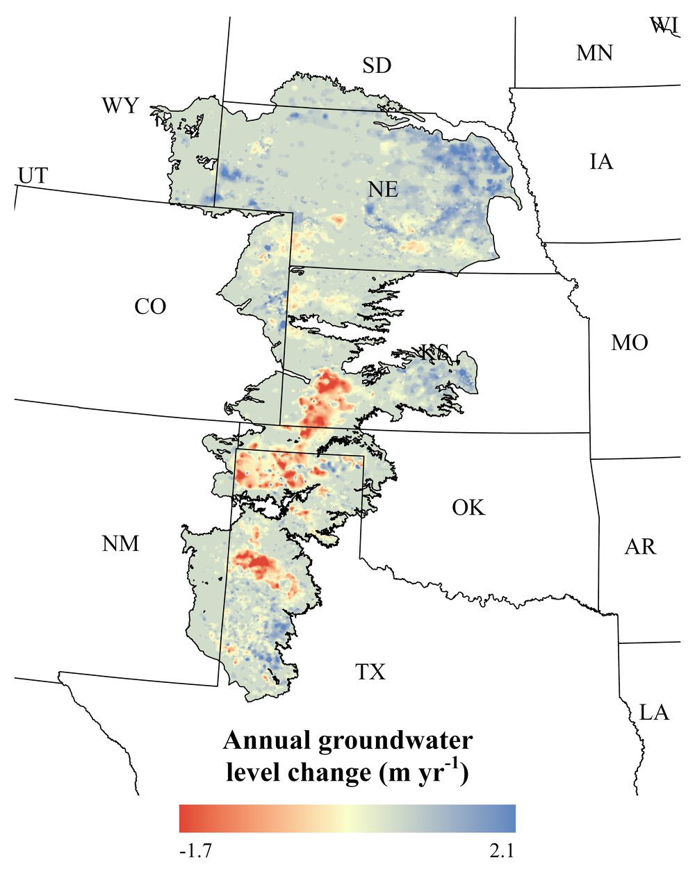
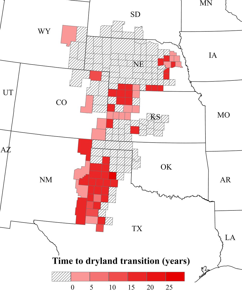
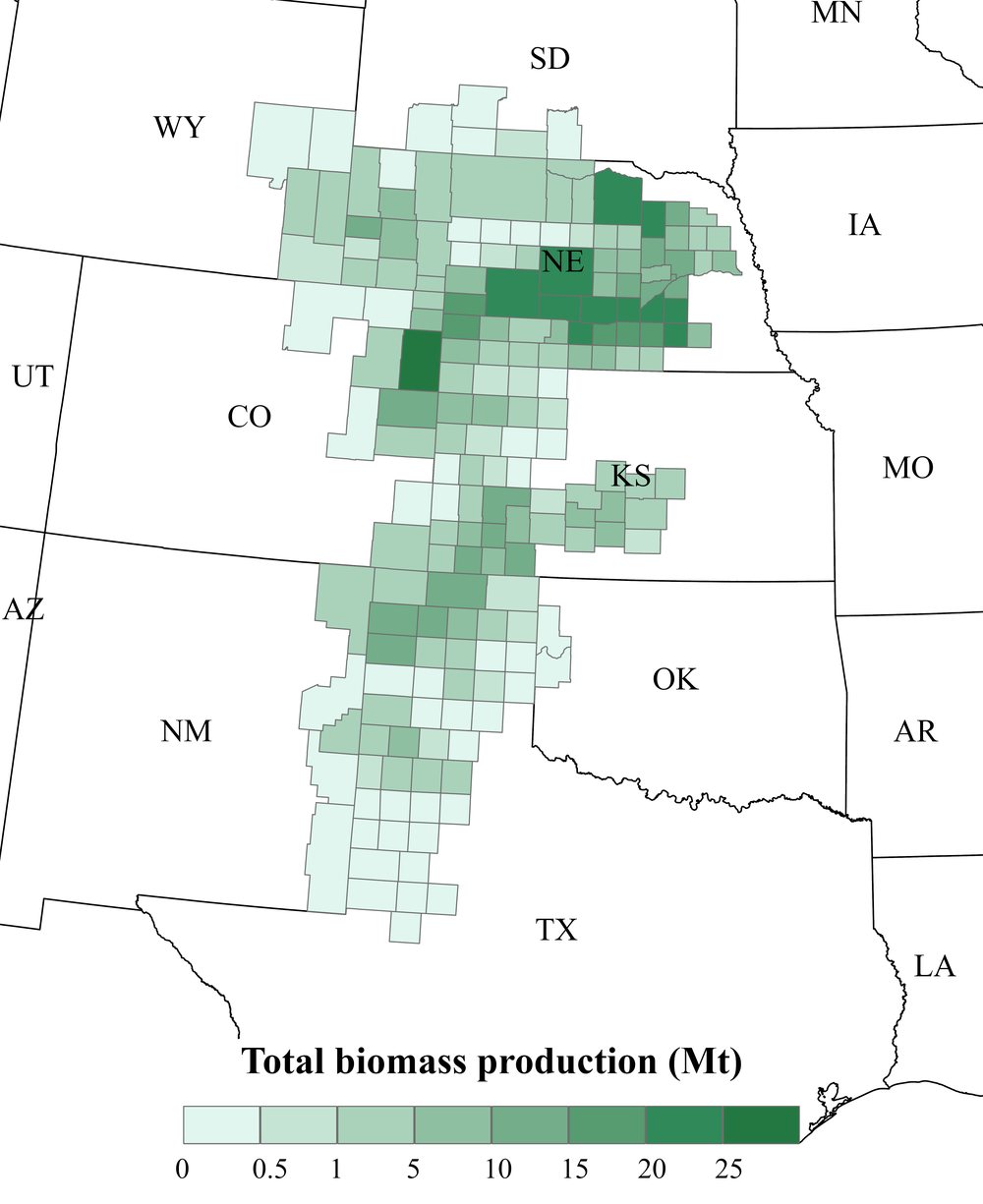
National map: K. Ramaswamy, from USGS Estimated Use of Water in the United States, County-Level Data for 2015 and the USGS High Plains Aquifer boundary (public domain). High Plains figures from Ramaswamy, Uludere-Aragon, and Lark (2026), Agricultural Water Management 334, 110675 (open access, CC BY). Click a map to view it at full size.
Current and recent projects focus on irrigation transitions, bioenergy crop systems, groundwater conservation, and agricultural decision-support tools.
A hydro-economic model evaluating how irrigated agriculture may transition under groundwater depletion, irrigation capacity constraints, crop profitability, and reinvestment decisions.
View project →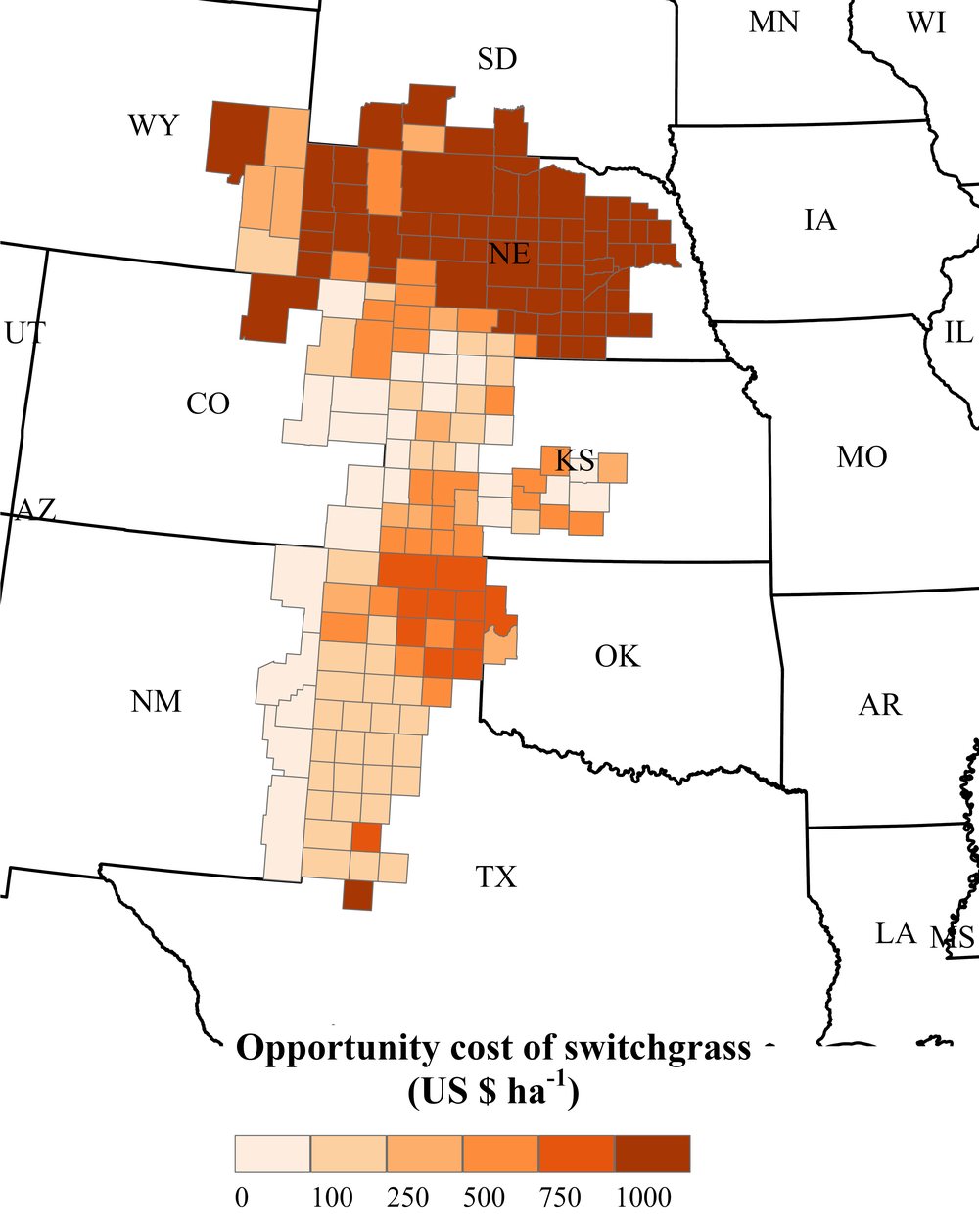
Research evaluating whether perennial bioenergy crops can support transitions from water-intensive irrigated agriculture while contributing to conservation and resilience goals.
View project →
An Excel/VBA and GIS-based decision-support tool for evaluating irrigation system upgrades using climate, crop yield, soil, slope, energy, and investment data.
View tool →Spatial data workflows linking crop production, irrigation status, climate, groundwater, soil, and economic variables for agricultural water systems analysis.
View tools & data →Selected manuscripts, tools, and applied research products related to groundwater sustainability, irrigation transitions, bioenergy crop systems, and agricultural decision support.
Agricultural Water Management, 334, 110675.
Evaluates how bioenergy crops and dryland transitions may support groundwater conservation and long-term agricultural adaptation in the U.S. High Plains Aquifer region.
Agricultural Water Management. Under review.
A 60-year farm–aquifer optimization for the Oklahoma High Plains estimates when maize gives way to grain sorghum as well capacity declines, and identifies well capacity per installed hectare as a candidate indicator of crop transitions.
AAEA Conference Proceeding.
Pilot study to evaluate the most economically viable non-irrigated agricultural systems in the U.S. High Plains Aquifer region.
Choices, 36(2).
Economic impacts of labor, water, trade, and regulatory issues in fruit farming in California.
I use quantitative, spatial, and computational methods to connect agricultural data, water-resource constraints, economic decisions, and regional land-use outcomes.
I welcome inquiries related to agricultural water management, groundwater sustainability, irrigation economics, land-use transitions, and decision-support modeling.